

In architecture, a site plan is a scaled drawing that fixes the proposed building against the boundary, easements, setbacks, existing structures and levels. Picture a rear extension at concept stage, with a parcel outline from the county map on one screen and a survey that hasn't arrived yet.
That outline will get the drawing started, but it can't settle where the boundary runs. This guide names the document that owns each line on the sheet, then sets out a drawing order.
Key takeaways
- Start from a parcel outline if that's all you have, then replace it with surveyed dimensions before you fix anything against it.
- Give every line an owner: the survey for the boundary, title documents for easements, the zoning code for setbacks and a topographic survey for levels.
- Read your own authority's list before you choose a scale, because the published figures differ between countries and cities.
- Draw in a fixed order: boundary, existing features, setbacks, proposed work, access and levels, notes, then the sheet.
- Show recorded easements from the first submittal, and make every dimension string add up to the overall property dimension.
What a site plan shows
San Diego's Information Bulletin 122 defines a site plan as "a drawing that shows all property lines, lot lines, easements, public rights-of-way, buildings and structures located on the parcel of property (existing and new)."
The Planning Portal says, "The site plan shows the proposed development in relation to the property boundary", and warns that a location plan "should not be confused with a site plan."
Read those definitions together and the job of an architectural site plan is clear. Record what is on the plot, then show how the new work sits inside it.
A floor plan stops at the walls of the building. A site plan starts at the boundary and treats the building as one object on the plot, with distances to everything around it.
UK validation lists also use the term block plan. Havant Borough Council says a block plan "shows the footprint of a proposal and detail of any changes to the existing boundary treatment."
A location plan is the wider map that fixes where the site is, and it is a separate drawing. A block plan is the UK name for a site plan on many validation lists. Plot plan is a common US term for a site plan centred on the lot lines. You may be asked for any of these. Ask what the drawing has to show, then follow the checklist of the authority that will read it.
What to put on a site plan
Put the boundary, every structure, the adjacent street and the levels on the sheet, then add whatever your authority's checklist names. The table sets four published checklists side by side, with each source linked in its column heading.
| Item | Portland Brochure 6 | Seattle Tip 103, August 2025 | San Diego Bulletin 122, May 2026 | UK Planning Portal |
|---|---|---|---|---|
| Boundary | Entire lot | Property lines and dimensions | All property lines and lot lines | Proposal shown against the property boundary |
| Easements | Location and dimensions | Location with King County recording number (enhanced list) | Easements | - |
| Setbacks | Lot and building setback dimensions | Front, side and rear distances from structures to property lines | Dimensions from buildings to property lines | - |
| Buildings | Footprints of proposed and existing structures, decks included | Location, size and shape, existing and proposed | Buildings and structures, existing and new | Size and position of the existing building and extensions, position and use of other buildings within the boundary |
| Street | Width of adjacent right of way, curb height | Right-of-ways and adjacent street names | Public rights-of-way | Position and width of adjacent streets |
| Levels | Property corner elevations, plus existing and proposed contours at 2-foot intervals over a 4-foot differential | Elevations and contour lines on sloping sites (enhanced list) | - | Separate site levels plan, with sections, when ground level changes |
| North arrow | Required | Pointing to the top of the sheet | Required on the site plan and the vicinity map | Contained on the site plan |
| Areas | Lot area, building coverage area and percentage, impervious area | - | - | - |
| Trees and services | Trees 6 inches or greater in diameter, utilities, stormwater facility, surface drainage | Protected trees, plus street trees and on-site stormwater (enhanced list) | - | - |
| Site identity | - | Address, legal description, assessor's parcel number | Site address, legal description, assessor's parcel number | - |
A dash means no entry from that checklist, so read the full document for your own job. Seattle's enhanced entries come from the longer of its two lists.
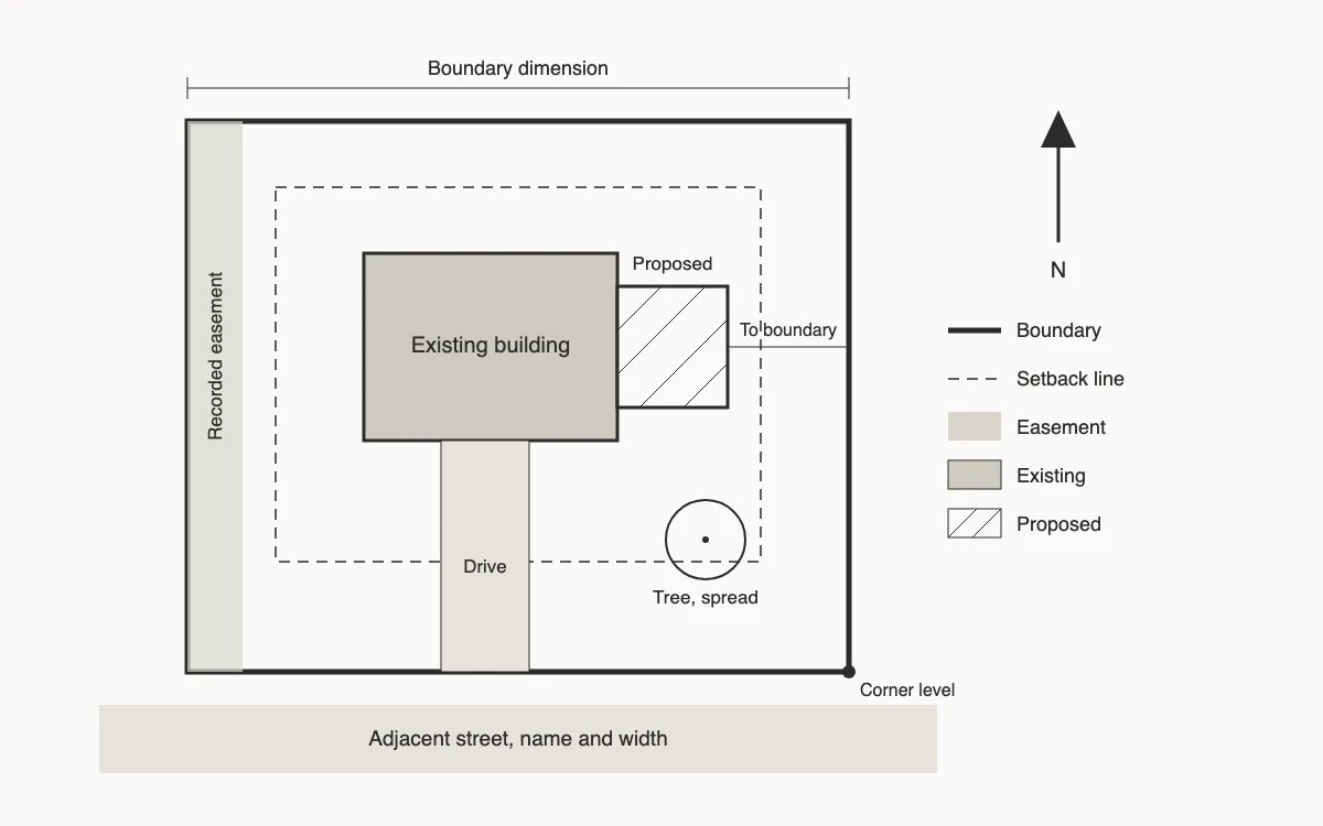
Draw the setback as a dashed line inside the boundary, then dimension the proposed work back to the boundary itself. A reader can then check the distance without scaling the sheet.
Where each line comes from
A parcel map owns none of the lines on a site plan, so give each one a named document before you rely on it. Two county mapping offices warn that their parcel lines are approximate.
Van Buren County, Michigan says of its parcel lines, "Some lines are relatively accurate, while others may be off 20 feet or more." One county's data tells you nothing about another's, so treat any parcel line as unverified until a survey confirms it.
Roane County, Tennessee says, "GIS parcel boundaries are approximate representations and should not be used as a substitute for a professional land survey." Use the table to decide what each shortcut can carry.
| Line on the plan | Document that owns it | How far to trust a parcel map or other shortcut |
|---|---|---|
| Boundary | Boundary survey by a licensed surveyor | Starting point only. Replace it with surveyed dimensions before you set out anything from it. |
| Easements | Title report and the recorded easement documents | Not at all for width or position. A clear strip on a map says nothing about what is recorded. |
| Setbacks | Zoning code or local planning rules, measured from the surveyed boundary | Only as far as the boundary behind it. An offset from a parcel line carries that line's error. |
| Existing buildings | Measured survey or as-built drawing | Context only. A map or aerial outline can miss extensions, decks and outbuildings. |
| Levels | Topographic survey | Early massing only. Take corner and floor levels from the survey, not from online terrain data. |
| Proposed footprint | Your design drawing, tested against the lines above | Only as far as the lines it was placed against. Test it again when the survey arrives. |

A survey can also carry formal weight. San Diego's bulletin strongly recommends a title report before site design, and says a site plan showing property lines, easements and fixed works "shall be sealed, signed and dated by a person authorized to practice Land Surveying". A current sealed topographic map and boundary survey may be provided instead.
That wording rests on California law, and your jurisdiction may differ. Ask early whether your authority wants a surveyor's seal on the drawing.
Which scale to use
Use the scale your authority names. If it names none, pick the largest scale that fits the whole plot and its dimensions on the sheet.
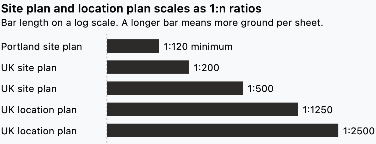
Portland's Brochure 6 says, "1 inch = 10 feet is the minimum scale accepted for site plans." One inch on paper stands for 120 inches on site, so that is 1:120.
The Planning Portal says site plans are "typically submitted at a scale of either 1:200 or 1:500", and gives "typically 1:1250 or 1:2500" for a location plan.
These figures come from different jurisdictions, so they don't conflict. A 1:200 sheet that suits a UK council would fall below Portland's minimum, because 1:120 is the larger drawing.
Test the whole plot on the paper before you commit to a scale. If the boundary and its dimensions won't fit, try a larger paper size before you drop to a smaller scale. Our guide to architectural drawing scales covers scale choice across the rest of the set.
How to draw a site plan, in order
Draw from what is fixed towards what you are proposing. Seattle's Tip 103 says, "it is usually easiest to begin by drawing the property lines. Next, add the existing features and then show proposed additions or changes."
Start with the boundary
If you only have an address, take the parcel outline from the county parcel viewer or, in the UK, a licensed map. Bring it to true scale against one known dimension, turn it so north is correct, and label it provisional on the drawing. In Synaps, you can search the address, then pick a parcel with its size and area shown or draw a custom boundary.
Keep the provisional outline apart from your design lines, so you can replace it when the survey arrives. When the survey arrives, draw a custom boundary in Synaps from its surveyed dimensions and stop using the parcel outline.
Walk the dimensions round the plot and confirm they return to the starting corner. A boundary that doesn't close has a transcription error somewhere.
Add what is already there
Locate existing buildings, decks, drives, walls and trees next. Take them from the survey or from as-built drawings, and measure on site where neither exists.
The Synaps site frame shows surrounding plots, buildings and trees, which gives you the context beyond your boundary.
Plot easements and setbacks
Plot each easement from its recorded document, and write its width on the drawing. Then offset each setback from the surveyed boundary, using the distance in the code, and note that distance on the line.
Place the proposed work
Set the proposed footprint apart from the existing structures with a hatch or a tone, and repeat that in the legend. Portland's checklist asks for distances between structures and property lines, so dimension every proposed wall that faces a boundary.
Add access and levels
Draw the drive, paths and the street edge, then label the street. Mark a level at each boundary corner and at the finished floor.
Carry those same levels into your elevation drawings, so the ground line agrees across the set.
Finish with line weights and notes
Property lines and buildings are usually heavy, and dimension and pavement lines are usually lighter, with notes and dimensions generally drawn last.
Set up the sheet
Place the whole plot on one sheet with the north arrow, scale and legend beside it. Put the drawing title, scale and revision in the title block.
A paper in Synaps takes a set format, orientation and scale, and exports as PDF or DXF.
Where site plans go wrong
Site plans go wrong when they leave out something the reader needs, or when the drawing disagrees with itself.
San Diego's bulletin says, "Failure to identify recorded easements on site plans during initial submittal will result in additional reviews, fees, construction changes and processing delays." Get the title documents before the first submission goes out.
Dimension strings are the next thing to test. Seattle's Tip 103 says the segments "through the property should add up to the overall property dimensions." Add up every string before you issue the sheet, and trace any difference back to one rounded figure.
Cropped sheets are another fault. Portland's Brochure 6 says, "The scale used must be clearly shown and the site plan must show the entire lot."
A fence on the ground is not proof of the boundary, because it may have been built to one side of the line.
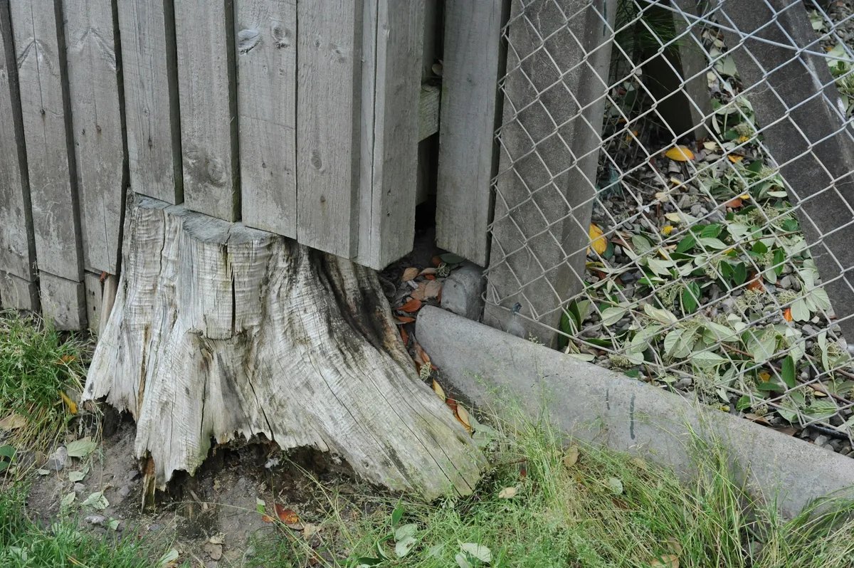
Draw fences as existing features, in their measured positions, and let the survey place the boundary. Where the two differ, tell your client before the design relies on either.
A UK planning set and a US permit set
A UK application splits the job between a map-based location plan and a site plan. The US checklists in the table name what the site plan itself must carry.
The Planning Portal says a location plan "must be based on an up-to-date map". The site and all land needed for the development, including access from the road, are outlined in red. Other land the applicant owns close by or next to it is outlined in blue.
Havant Borough Council says plans should "be purchased within the last 12 months from a licensed reseller" and should not "be a photocopy or screen grab". For that council, a screenshot of an online map won't do, so budget for a licensed copy.
Havant also keeps block plans lean. Its guidance says they "should only include features that would influence or be impacted by the proposed development."
Portland's list runs the other way, and it carries practical sheet rules. Portland's brochure sets a minimum size of 11 x 17 inches and asks for white space for approval stamps. Leave that space when you lay out the title block.
San Diego's bulletin asks for a vicinity map that needn't be to scale but shows at least two major cross streets. Requirements change between authorities, so take your list from the one reading the drawing.
Site plans in Synaps
Synaps gives you an editable site plan that belongs to the same project as your floor plans, sections, elevations and 3D.
- Search the address of the plot.
- Pick a parcel to see its size and area, or draw a custom boundary from surveyed dimensions.
- Rotate the site to suit your drawing.
- Use the site frame to see the surrounding plots, buildings and trees.
- Connect your building to the site.
- Draw easements, setbacks and level marks, and add notes, on the site plan, which is an editable drawing surface.
- Place the site plan on a paper at your chosen scale, and export it as PDF or DXF.
Parcel coverage depends on location. A picked parcel is a starting point, and the survey sets the legal line.
If your next job starts from an address and a parcel outline, try Synaps for free and set up the boundary for that plot.
FAQ
Do I need a survey before I start a site plan?
You can start concept options without one, because early massing can work from an approximate plot. Order the survey before you fix setbacks or issue a dimensioned drawing. Ask the surveyor for the boundary, levels and existing features on one drawing, so every line starts from the same survey.
Can I use an aerial image as the base for a site plan?
Use one for context only. An aerial view shows roof edges rather than wall lines, and tall buildings can lean away from the camera, so positions taken from it drift.
Should a site plan show neighbouring buildings?
Show them in outline where the proposal comes close to them, or where they affect access, light or overlooking.